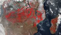
NASA's Suomi NPP satellite imaging system spotted hundreds of fires in southern Africa. You can see them outlined in red. It's likely about half of the fires were deliberately set as part of a slash and burn land management plan. The fires can help improve crops and pastures, but hurt air quality.
NASA is tracking wildfires globally, offering a view from high above Earth that reveals the scope and size of major fires, some of which produce smoke plumes that stretch for miles.
Photo Credit: Jeff Schmaltz, MODIS Rapid Response Team
No comments:
Post a Comment